In July 2025, the Voyis team successfully completed the IMAGE2 project (Image Modelling & Analysis for Governance and Education), marking a significant milestone in advancing subsea monitoring technologies for marine conservation. Funded by Fisheries and Oceans Canada (DFO) through the Oceans Management Contribution Program, this initiative builds upon the success of the original IMAGE project, where Voyis demonstrated the effectiveness of deploying high-resolution underwater optical sensors on small ROVs to monitor Sponge Reef Marine Protected Areas (MPAs) off the coast of British Columbia.
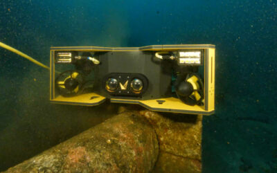
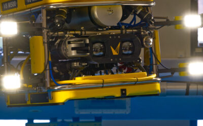
In IMAGE2, the focus shifted toward enhancing this capability by developing a fully integrated, built in Canada subsea survey solution that is cost effective, portable, and scientifically robust. The project was conducted in partnership with two leading Canadian ocean sector organizations: MarineNav Ltd. and the Fisheries and Marine Institute of Memorial University. Together, the partners created a compact ROV-based platform, combining MarineNav’s Oceanus ROV with Voyis’ Discovery Stereo Inspection Series I300 Camera.
Enhancing Marine Protected Area Monitoring
The IMAGE2 project directly supports Canada’s national goals for ocean conservation and sustainable resource management. By enabling more accessible and scalable monitoring of sensitive marine habitats, the project contributes to improved governance of marine spaces through advanced science and stakeholder engagement.
The developed solution was operationally validated through a 3D survey of the newly discovered Coral Garden within the Funk Island Marine Refuge—an ecologically significant area off the coast of Newfoundland. This region features delicate cold-water coral structures, whose physical complexity and biodiversity require careful, non-intrusive observation. The Voyis Discovery Stereo I300 Camera captured detailed optical data that will be processed into complete, georeferenced 3D reconstructions of the site.
Leveraging 3D Subsea Imaging for Science and Stewardship
Voyis’ optical imaging system not only provides high-resolution video and stills but also generates true-scale 3D models of the seafloor environment. This volumetric data gives researchers and conservation authorities the ability to assess coral distribution, reef health, and habitat structure with unprecedented accuracy.
These reconstructions offer more than just visual representation, they establish a critical baseline for long term ecosystem monitoring. The ability to revisit and compare the same coral formations over time supports efforts to track environmental change, measure human impact, and guide protection measures for vulnerable marine ecosystems.
As part of the project’s commitment to transparency and accessibility, all collected data, including 3D models and ecological insights, will be made publicly available. This initiative promotes collaboration across scientific institutions, policymakers, and coastal communities.
“Here in Newfoundland and Labrador and across the country, we continue to learn more about our vast and diverse oceans and all they sustain. The IMAGE2 Project led by Voyis is an example of how Canadian-made technology and local expertise can help us better understand sensitive ocean habitats and further our efforts in marine conservation and the sustainable management of resources.”
– The Honourable Joanne Thompson, Minister of Fisheries
Built-in-Canada Innovation and Collaboration
The IMAGE2 platform represents a new standard for marine science fieldwork: affordable, portable, and tailored for real-world conditions. MarineNav’s compact Oceanus ROV served as the foundation for integrating Voyis’ specialized optical sensor, creating a streamlined system suitable for shallow and complex underwater environments.
The Marine Institute played a crucial role in executing the field survey and will also host a workshop to disseminate the project results. This educational component of the project aims to empower students, researchers, and conservation professionals with the knowledge and tools to apply advanced imaging technologies in their own work. The workshop, to be held at The Launch, the Marine Institute’s ocean innovation hub in Holyrood, will feature hands-on demonstrations, breakout sessions, and discussions on the future of subsea monitoring.
Looking Ahead
By combining innovation, science, and outreach, IMAGE2 demonstrates what’s possible when Canadian ocean technology companies and academic partners work together to advance sustainable marine practices. The portable 3D imaging solution developed through this project will enable broader participation in marine monitoring and unlock new potential for data-driven conservation.
Stay tuned as Voyis and our partners continue to share updates, data sets, and research findings from the IMAGE2 project, helping to illuminate the unknown and protect the biodiversity beneath our oceans.