Hibbard Inshore partnered with NOAA‘s Great Lakes Environmental Research Laboratory to expand their capabilities for under ice research in our Great Lakes.
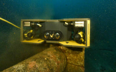
With that in mind, Hibbard and NOAA (National Oceanic Atmospheric Administration) turned to Voyis to improve their subsea capabilities. Their SAAB Sabertooth, equipped with Voyis Insight Pro underwater laser scanner and Observer stills camera, flew numerous autonomous survey routes.
The Project
This winter, NOAA and Hibbard are conducting test deployments of a SAAB Sabertooth autonomous underwater vehicle (AUV) in Lake Michigan, to collect ecological and water quality data under lake ice. Most fieldwork occurs during the ice-free seasons, so observations of winter ecology are challenging to obtain, making this hunt for winter data fundamental.
In the world of Great Lakes research, the start of winter traditionally signals the end of fieldwork for the year. That is when scientists start working on the data collected during the previous field season and tuning up field equipment for a fresh start in the spring. This break leads to a long gap in most of NOAA Great Lakes Environmental Research Laboratory’s field data. With that in mind, this project aims to fill that gap using the high-tech SAAB Sabertooth AUV and Voyis underwater optical sensors.


High-Resolution True Colour Underwater Camera
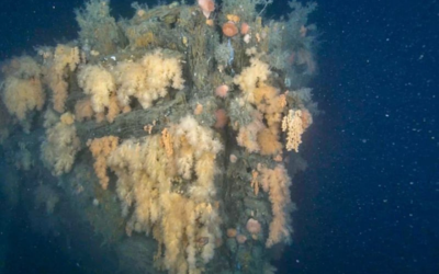
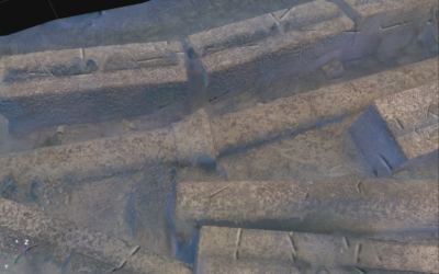
The SAAB Sabertooth has a Voyis Insight Pro underwater laser scanner and Observer stills camera. The Insight Pro captures high-resolution point cloud data for 3D reconstruction of the underwater world, allowing NOAA to acquire reliable benthic data, with a detailed map of the lake floor.
The Observer camera will output true colour 4K images, which are processed and enhanced in real-time onboard the system to deliver actionable data for species classification and identification while depicting the ecosystem’s health.
The Voyis underwater optical sensors will enable NOAA to map the locations of invasive mussel reefs on the lake floor and capture benthic data.
Autonomous Subsea Survey
In addition to the SAAB Sabertooth AUV, this project also includes the deployment of a fully integrated docking station that allows the vehicle to recharge its battery and transfer the data it collected during the winter excursion. The vehicle’s ability to safely dock, charge its battery, and transmit data to scientists is critical in functioning under the ice without human help as a fully autonomous subsea operation.
During the first trials, the AUV autonomously navigated through the Muskegon Channel and Lake Michigan, where it successfully collected ecological data and mapped the lake floor. When the AUV returned to the channel, it autonomously docked itself, using Sonardyne INS (Inertial Navigation Systems) to confirm its location. Once docked, the AUV transferred the collected data and successfully recharged its battery from a Teledyne Energy Systems Subsea Supercharger® hydrogen fuel cell. As a genuine ground-breaking outing, this field trial was the first time the Saab AUV has been charged underwater using a fuel cell power source.
Contact us to learn more.