With recent geopolitical events, it is more important than ever that we understand subsea technologies and how they can help us prevent and manage the crisis.
In September 2022, the Nord Stream natural gas pipelines in the Baltic Sea suffered a series of explosions which led to methane leak, and affected the transport of natural gas from Russia to Germany.
The methane clouds are being monitored closely. The ICOS, which is analysing the air quality, has shown footage of a huge gas cloud hovering above the Baltic Sea, and moving across Europe. Methane measuring stations in Sweden, Norway and Finland have indicated sharp rises in methane in recent days.
How Optical Systems Could Help
The Voyis Recon LS System enables uncrewed underwater vehicles to capture high resolution laser point cloud data, and 4k stills images. The detailed data collected can be used to perform predictive maintenance by 3D modeling assets in great detail with change detection, provide situational awareness around critical infrastructure, and offer inspections of affected assets following attacks, for forensics to identify how these attacks happened.

After an incident like the one we saw in September, the safest option is to deploy a robotic system, such as an Autonomous Underwater Vehicle (AUV). The AUV will assess the area and determine the cause of the accident, considering the state of the asset is highly volatile with unknown additional dangers.
Equipping these robotics systems with quantitative 3D laser scanners and qualitative stills cameras to capture the greatest level of detail possible ensures that we can safely assess the situation with greater confidence, without bringing humans in the face of further potential threats.
Using underwater vehicles to generate high resolution micro-bathymetric maps and wide area stills mosaics of the damage allows operators to determine the source of the explosion, potentially who the instigator was, and provide a completely accurate assessment for remediation and repair of the affected asset.
High Resolution Underwater Laser Scanner
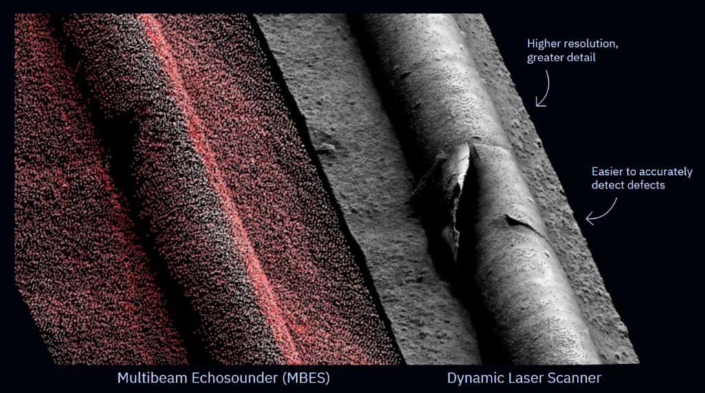
Compared to traditional survey solutions, underwater laser scanners and capable 4K stills imaging systems provide greater levels of detail when inspecting critical subsea infrastructure, as seen in the picture above.
Sonar systems offer centimetric levels of detail for understanding the general state. However, they do not provide enough detail to make confident decisions on the integrity of the asset as the data resolution results in interpretation by the operator and is subject to human error.
Increasing the resolution of the data collected offers operators more clarity in the condition of their subsea assets and provides immediate answers to the pressing questions of whether their assets are in a good state, or whether they are being tampered with.
Additionally, having datasets collected with georeferenced positioning allows operators to gather a greater understanding of their assets over time, using volumetric change detection to quickly determine what has newly been introduced to the subsea environment. This change detection model can also be used to develop a proactive maintenance regime to ensure your assets are not failing because of environmental conditions, minimizing the likelihood that a failure was unprovoked.

The Future of Subsea Inspections
As the enemy continues to become more aggressive and advance its pressures on critical subsea infrastructure located in international waters, nations will need to be proactive in ensuring their assets are safe.
The notion of seabed warfare is becoming more predominant and expansive, where Navies will need to leverage the latest technology, such as Voyis underwater laser scanner and stills cameras. Our optical sensors will accurately protect assets, gather seabed intelligence, and efficiently identify threats while using AUVs to reduce human risk.

Click here to learn more about how Voyis technology can be used in the Defence industry.