
Introduction
Inspection of large-scale hydraulic and marine infrastructure is fundamentally a problem of scale, accessibility, and data reliability. Vertical surfaces such as canal walls, quay walls, and similar engineered or natural boundary faces must be assessed for cracking, material loss, and structural degradation under conditions where direct access is limited and visibility can be highly variable.
Conventional inspection approaches, diver-based visual surveys and acoustic methods, provide partial solutions but introduce significant limitations. Diver inspections are inherently subjective and difficult to scale across large surfaces, while sonar-based techniques lack the spatial resolution required to resolve fine structural features such as narrow cracks or small-scale material loss.
As asset owners move toward data-driven maintenance strategies, there is an increasing requirement for inspection methods that deliver:
- Complete and verifiable coverage
- High spatial resolution across large areas
- Metric accuracy suitable for engineering analysis
- Digital outputs that support repeatability and long-term monitoring
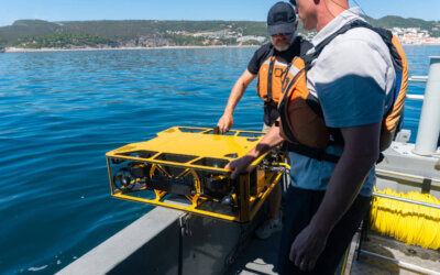
This case study presents the use of the Discovery Stereo Camera to inspect a 67-meter vertical natural canal wall, demonstrating how a structured optical workflow can overcome the limitations of traditional approaches while enabling detailed geometric and quantitative analysis. The methodology is directly applicable to similar vertical infrastructure such as quay walls, port structures, and dam faces.
Operational Challenge: Scaling Inspection Without Compromising Accuracy
The inspected wall represents a large vertical natural canal boundary, characterized by:
- Large vertical extent (67 m)
- Heterogeneous surface composed of exposed rock and localized man-made modifications
- Presence of cracks, voids, and surface irregularities
- Non-uniform texture and lighting conditions
The primary technical challenge is not simply detecting defects, but doing so in a way that ensures:
- Continuity of data across the full structure
- Consistency of resolution from top to bottom
- Geometric accuracy sufficient for measurement and comparison over time
Limitations of Conventional Methods
Diver-based inspections:
- Provide localized observations without full spatial context
- Depend heavily on operator experience and visibility conditions
- Do not inherently produce measurable or repeatable datasets
Multibeam or imaging sonar:
- Effective for large-scale geometry but limited in resolving fine features
- Insufficient for accurate crack width measurement or small-scale degradation
- Often require complementary datasets for detailed analysis
Standard monocular video:
- Lacks inherent scale without external references
- Cannot reliably support metric measurements
- Limits post-processing to qualitative review rather than quantitative analysis
These limitations create a gap between inspection data collection and engineering decision-making, particularly when precise measurements and volumetric assessments are required.
Workflow Overview
To address these challenges, the inspection was conducted using a structured workflow that integrates navigation, imaging, and quantitative analysis:
- Real-time data acquisition with coverage validation (VSLAM)
- Dense, high-resolution 3D reconstruction
- Quantitative crack detection and measurement
- Volumetric analysis of material loss and surface change
Each stage is designed to reduce uncertainty and ensure that the final dataset is both complete and metrically robust.
1. Data Acquisition and Coverage Validation
A critical limitation of large-scale inspections is the inability to confirm, during acquisition, whether sufficient data has been collected. Gaps in coverage or insufficient overlap often only become apparent during post-processing, leading to costly rework.
To address this, the inspection utilized visual simultaneous localization and mapping (VSLAM) to provide real-time feedback on vehicle position and coverage. This enables:
- Continuous tracking of the sensor relative to the wall
- Verification of full spatial coverage during the mission
- Immediate identification of areas requiring additional passes
The operator conducted systematic vertical and lateral transects, maintaining controlled stand-off distance and image overlap to ensure optimal reconstruction conditions.
Why This Matters
Ensuring coverage at the point of capture is critical for large assets such as vertical quay walls, canal boundaries, and dam faces. Without this capability:
- Small gaps can propagate into significant blind spots in the final model
- Reconstruction quality may degrade in under-sampled regions
- Additional mobilizations may be required
By integrating the Voyis VSLAM solution into the workflow, data quality becomes proactive rather than reactive, significantly improving operational efficiency and dataset reliability.
2. High-Resolution 3D Reconstruction
Following acquisition, the stereo imagery is processed to generate a dense 3D reconstruction of the wall.
Unlike monocular systems, stereo imaging provides direct depth estimation, enabling the generation of:
- Scaled and metrically accurate point clouds
- High-resolution surface meshes
- Photorealistic texture mapping for visual interpretation
This is particularly important for complex natural rock surfaces and engineered boundaries, where small geometric variations such as crack edges or localized material transitions must be preserved.
Why Stereo Imaging Is Critical
The use of a calibrated stereo system addresses several key limitations:
- Eliminates reliance on external scaling references
- Maintains consistent measurement accuracy across the full 67 m extent
- Preserves fine structural details that would be lost in lower-resolution systems
Additionally, reconstructing the surface as a continuous model provides essential spatial context, allowing engineers to understand how localized defects relate to the broader structure.
3. Crack Detection and Measurement
Crack identification is a primary objective in infrastructure inspections, but detection alone is insufficient. Engineering assessment requires quantitative characterization.
Using the high-resolution 3D model, cracks can be:
- Precisely located within the global structure
- Measured in terms of length, width, and orientation
- Compared across different inspection campaigns
Measurements are performed directly within the 3D dataset, ensuring that results are:
- Scaled and repeatable
- Independent of operator interpretation during acquisition
- Traceable within a digital inspection record
Why Measurement Capability Is Essential
Without accurate measurement:
- Crack severity cannot be reliably classified
- Progression over time cannot be quantified
- Maintenance decisions rely on subjective judgment
By enabling metric measurements, the workflow transforms inspection data into actionable engineering inputs, supporting risk assessment and maintenance planning.
4. Volumetric Analysis of Surface Degradation
In addition to linear defects, vertical hydraulic and marine structures such as canal walls, quay walls, and dam faces are subject to material loss mechanisms including erosion, spalling, and mechanical wear.
The 3D model enables volumetric analysis by allowing operators to define regions of interest and calculate:
- Volume of missing or degraded material
- Surface deviation relative to surrounding areas
- Extent and distribution of damage
- Scour/Undermining
Why Volumetric Analysis Matters
Surface degradation is often difficult to assess using traditional methods, particularly when:
- Changes are gradual or distributed
- Visual inspection lacks depth perception
- No baseline exists for comparison
Volumetric quantification provides:
- A direct measure of material loss
- A basis for prioritizing repair interventions
- A repeatable metric for monitoring changes over time
This represents a shift from qualitative observation to quantitative condition assessment.
Results and Key Outcomes
The inspection of the 67m vertical canal wall demonstrates that high-resolution stereo imaging, combined with a structured workflow, can deliver:
- Complete and verifiable coverage of large vertical infrastructure
- Consistent high-resolution reconstruction across the full structure
- Accurate and repeatable crack measurements
- Quantitative volumetric analysis of surface degradation
Importantly, the integration of Voyis VSLAM Powered by EIVA NaviSuite ensures that data completeness is verified during acquisition, reducing uncertainty and minimizing the need for repeat inspections.
Conclusion
Large-scale inspections of vertical hydraulic and marine infrastructure require more than visual documentation, they demand accurate, complete, and measurable datasets that can support engineering decision-making.
This case study demonstrates that the Discovery Stereo Camera enables a transition from traditional inspection methods to a fully digital, measurement-driven workflow, where:
- Coverage is validated in real time
- Geometry is captured with metric accuracy
- Defects are quantified rather than estimated
- Structural changes can be monitored over time
Such capabilities are essential for modern asset management strategies across canal systems, quay walls, port infrastructure, and dam faces, where reliability, repeatability, and data integrity are critical.