The Voyis Perception ROV Skid was built to improve efficiency of inspection class ROVs (Remotely Operated Vehicles), by creating an all-in-one solution for these portable subsea vehicles.
By bringing together optical sensors, navigational systems, and software, the Perception Skid is a complete solution for ROV inspections.
In today’s post we will explain more about what the ROV skid is, and its benefits for subsea operations. In addition to that, in the upcoming weeks we will go over how the skid can enable autonomy for ROV operations, and how it can be used in different applications for offshore energy, ocean sciences, civil infrastructure, and Defense.
What is the Perception ROV Skid?
The Perception Skid is a pre-configured frame that contains all the required sensors to perform highly detailed dynamic laser modeling and subsea imaging. All sensors are factory calibrated and tightly integrated together so that the skid can be quickly connected to the ROV of your choice for rapid mobilization.
The Perception ROV skid has both the underwater optical sensors and the navigational sensors accurately co-located with system offsets defined to ensure that there is no requirement for customers to perform a patch test before their survey.
The connection to all required sensors installed in the Skid is simplified, there is a single power and communication line to connect to the vehicle. Additionally, the Skid includes a “Quick Connect” mounting systems where the frame can easily mount to the vehicle without the need for tools, optimizing in-field installation and ease of swapping out sensor packages to perform multiple survey objectives
The Technology
The Voyis Perception Skid includes an incredibly powerful optical survey sensor with 3D modelling and image mapping capability from small ROV platform. Coupled with highly accurate subsea navigation sensors for confident subsea data and vehicle positioning. The specific technology used within the Perception Skid includes:
- Voyis Insight Micro Laser Scanner & Stills Camera: mounted in a downward configuration for seabed survey, it outputs high-resolution data corrected in real-time for eventing identification and 3D reconstruction of the assets inspected. Additionally, the scanner can be mounted in the forward-facing orientation for modeling assets in the water column, or side mounted for traversing larger assets.
- Sonardyne SPRINT-Nav Mini Inertial Navigation: an all-in-one Inertial Navigation system that combines an accelerometer/Gyro with a DVL (Doppler Velocity Logs) and depth sensor, for highly accurate global positioning. Though the navigation data is used to aid the optical data, it also delivers significantly improved ROV positioning for piloting and autonomy
Benefits of the Perception ROV Skid
This Voyis engineered solution delivers a truly plug-and-play design. The skid has foam buoyancy designed into the frame, ensuring that it is both neutrally buoyant (no weight in water), and balanced in both pitch and roll for non-disruptive vehicle control.
This design ensures it can be instantly connected to the bottom of the ROV and not have any impact on vehicle dynamics or trim, enabling the swapping of different payloads for different tasks.


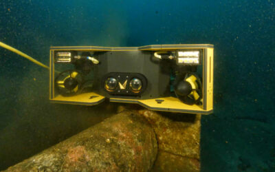
The pictures above show the VideoRay Defender ROV with the Perception Skid, which utilizes the “quick connect” interface to allow the skid to be mounted in less than a minute.
Subsea cables from the Voyis Insight Micro and the Sonardyne SPRINT-Nav Mini are simply connected to the Defender’s auxiliary sensor box, which will broadcast data over the vehicle’s central ethernet network. This technology allows the data to be streamed topside for real-time data viewing throughout the survey.
The Perception ROV Skid collects both underwater 3D laser data and colour imagery in real-time, utilizing the highly accurate SPRINT-Nav Mini INS (Inertial Navigation Systems) to create high-resolution georeferenced data outputs.
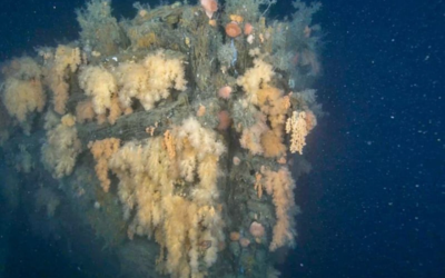
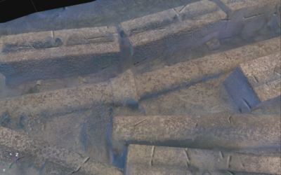
The underwater 3D laser generates data for high accuracy 3D asset inspection, mine identification, marine environmental modelling, micro-bathometry, and much more. The colour images captured are processed with machined learning for true colour image maps, a feature that truly brings the ocean to life. The images can be directly utilized in standard photogrammetry software to produce incredible seabed maps or colorized 3D models of targets like shipwrecks and coral environments.
All this capability is now available on low logistic, easily deployed, small ROV platforms – download our datasheet to learn more.