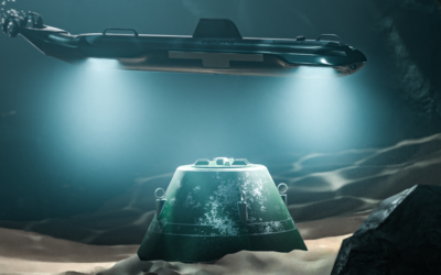
Underwater asset inspection is undergoing a major transformation as the industry shifts from traditional 2D visuals to advanced 3D geospatial modeling. With technologies like Voyis VSLAM Powered by EIVA NaviSuite, operators can now capture three-dimensional models of underwater assets in real time. This shift enhances the reliability of data, providing a detailed spatial context that enables operators to better assess asset condition and make informed decisions.
GVI + 3D Modeling: A Comprehensive Approach to Asset Condition Assessment
Integrating General Visual Inspection (GVI) with 3D modeling has elevated underwater asset inspection to a new level. GVI + 3D brings together clear, detailed visuals and precise spatial measurements, offering operators both qualitative and quantitative insights. This approach supports a more comprehensive understanding of asset conditions, helping to accurately identify and track potential issues over time.
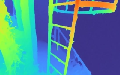
Key to this process is VSLAM (Visual Simultaneous Localization and Mapping), which powers the transformation of optical data into accurate 3D point clouds in real time. By mapping images with spatial accuracy, VSLAM technology allows underwater vehicles equipped with the Discovery Stereo Vision System to create real-time maps of complex structures. For example, when combined with photogrammetry, the EIVA and Voyis VSLAM solution captures fine details even on intricate, irregular surfaces, reducing the need for repeated inspections by delivering thorough, precise data in a single pass.
From Inspection Data to Geospatial Insights
3D-enabled inspections provide more than just visuals; they offer actionable geospatial insights. Transitioning from 2D imagery to 3D models provides quantifiable datasets, enabling operators to measure distances, monitor changes, and detect material loss avoiding the guesswork involved when making assessments only based on images. By incorporating spatial awareness, these models transform raw visual data into reliable insights that guide maintenance and risk management.
Quantifiable 3D reconstructions of assets are especially beneficial for ongoing asset monitoring, allowing operators to track changes over time and compare data across multiple inspection cycles. This capability strengthens both predictive maintenance and long-term risk assessment, empowering operators to address potential issues proactively.
Additionally, the spatial insights provided by 3D technologies extend the value of inspections beyond asset maintenance. Offshore infrastructure managers, for instance, gain a clearer understanding of how assets interact with surrounding environments, an important consideration for maintaining environmental stewardship in sensitive areas.
Advancing Underwater Inspections with Voyis VSLAM Powered by EIVA NaviSuite
Voyis VSLAM Powered by EIVA NaviSuite represents a major leap in underwater asset inspection, offering a streamlined approach that reduces setup time while optimizing inspection efficiency. The collaboration between Voyis and EIVA brings together advanced capabilities to deliver spatially accurate 3D models, improving both visual quality and measurement precision.
This VSLAM solution supports a wide range of inspection needs, from complex structural assessments to routine maintenance checks, ensuring operators receive complete geospatial data in one integrated workflow. This shift in inspection methodology marks a new era where high-quality, spatially accurate data is standard.
The transition from 2D to 3D modeling is redefining underwater asset inspection, giving operators access to more reliable and informative data than ever before. By combining detailed visual clarity with precise spatial measurement, 3D technology enhances the quality of underwater inspections, paving the way for improved analysis, predictive maintenance, and proactive risk management. As 3D inspection technology continues to evolve, it promises a future of increasingly powerful and informative underwater asset inspection solutions.