Ocean surveyors have historically relied on subsea video cameras deployed in underwater vehicles for environmental monitoring, general inspection, and underwater situational awareness. But the operating mechanism of “video” significantly limits the ability of advanced image processing and machine vision. Conversely, stills imaging provides revolutionary advantages when used correctly.
Voyis endeavours to produce underwater imagery where the effects of the water medium are entirely removed. Which will enable the use of standard terrestrial processing algorithms like photogrammetry and machine learning. In fact, this is a core focus of our mission to See the Depths like We See the Surface.
This blog is part of our Colour Imaging series. This edition will focus on our colour correction technology and how it can improve underwater imaging results.
Underwater Colour Absorption
In order to understand the challenges with colour image correction underwater, we must first understand the problem. Humans perceive colour based on how different wavelengths of light (colour channels) reflect off objects and reach our eyes. In air, all colour channels (red, green, blue) are absorbed roughly equally. Which means, an object like a wooden ship is perceived as brown because it reflects mostly red and green wavelengths.
However, since the red wavelengths are absorbed more by water, the perceived colour of the shipwreck is altered. Standard cameras are not designed to account for this underwater colour shift, as their colour formation model neglects the strong wavelength dependency of light underwater.
Therefore, our goal is to produce underwater images with colours shown as they would be perceived in air. Explorers are able to visualize the true colour of subsea assets, and uncover details not prevalent with standard cameras.
Another challenge for a survey-grade colour correction solution is consistency. An image dataset for photogrammetry has features that must match in the image sequence when observed from different perspectives (different times). At each perspective, both the perceived colour of the feature will have changed (different distance) and the lighting distribution will be altered, as the artificial light source moves relative to the feature. A solution must therefore balance both colour reproduction effectiveness, and image-to-image consistency.
Solution
To address this complex problem, Voyis has developed a survey-grade imaging solution suitable for a range of applications. Leveraging machine learning to efficiently train a colour Correction Model for the current survey location.
The first step towards this goal is collecting raw stills images. An unaltered image information that is recorded before the camera applies its air-based colour formation model.
With the Voyis imaging system, once an image dataset is collected in a new environment, it can be inputted into ViewLS Data Module software to train a Correction Model. A file is saved which can be both applied to correct the current dataset, as well as loaded onto the imaging system for real-time correction in similar environments.
Though real-time image correction is often preferred, carried out onboard the stills camera users can also use the raw images in post-processing to further optimize the results.
The result is highly effective at accurately adjusting an image’s colour channels. And also ensuring sequential images are consistent in both illumination and colour by using a generalized model.
This correction transformation is shown in the below image set. The raw monochrome image is first undistorted, then finally corrected to its true colour with the application of the Correction Model.

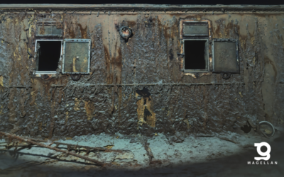
Since the images have been consistently corrected to remove all aspects of the water medium – colour, lighting, and distortions – the output dataset can be directly utilized in terrestrial photogrammetry software. Thus producing incredible wide-area image maps (orthomosaics) and 3D models. The model below was created in Pix4D software by simply dropping in a set of images collected from two passes over the wreck.

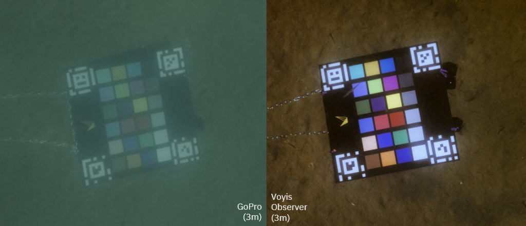
When the colour reproduction is validated against standard colour charts, we see a drastic improvement over a camera using standard image colour formation. The below comparison shows a colour chart captured at 3 meters range in clear coastal waters, using a standard GoPro camera and the Voyis Observer Micro.


