We recently had the incredible opportunity to interview Adam Taylor and Glen Dennison, the President and former President, respectively, of the Marine Life Sanctuaries Society of British Columbia.
Adam and Glen were able to provide us an unique perspective on the importance of glass sponge reefs, and why this fragile ecosystem must be studied to be properly preserved. With that in mind, we discussed how mapping projects, like the IMAGE project, can help them accomplish their preservation goals.
Can you explain the importance of MLSS’ work in marine preservation in British Columbia?
We are a unique organization, the Marine Life Sanctuaries Society is volunteer based, we do a lot of citizen science and local and regional meetings with First Nations and local regional governments. We are very dedicated to studying and learning as much as possible about the local habitat, we are in the field building local support. Our organization is very hands-on, so what sets us apart is the citizen science work we do, which allowed for many discoveries in the past century about marine life in the region. MLSS is the only organization in the region that science’s contribution led to protection, by working with the Department of Fisheries and Oceans we’ve started the rockfish conservation areas and the glass sponge areas too. In addition to that, our team is not averse to thinking outside the box, our goal is to preserve that environment and we will work with every level of government to achieve that.
MLSS is a volunteer-based organization and our approach to conservation is very hands-on. Our strength and success come from local collaborations, data collection & mapping so in many cases our work directly drives the conversation on conservation measures.
Can you talk about the particularities of Howe Sound and the importance of that region?
There’s a significant amount of freshwater influx which impacts the type of marine life and then there’s also, of course, the fact that it’s extremely steep and deep, 1100 feet just north of the glacial sill – and then seven to eight hundred feet in much of the rest of it. Another important aspect of the region is that we are right outside of Vancouver harbor so not only is there existing industrial & commercial uses but there’s a very high recreational value for the area – boating, hiking, nature watching, recreational fishing. Howe Sound is protected with fishing closures but there’s still people who try to infringe the rules and pose a significant threat to glass sponge reefs and other marine life.
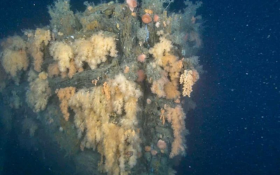
One other aspect to know about this region is the fact that glass sponge reefs really only exist off the west coast of British Columbia, Howe Sound actually holds the most pristine glass sponge reefs in the entire world, because they weren’t bottom dragged and extensively damaged before they were discovered.
What is the importance of preserving glass sponge reefs in Howe Sound?
There’s a huge environmental importance, since they were vastly destroyed before they could be studied. The arrival of the Europeans into North America was the decline time for the glass sponges, and they work on a different clock than humans. Glass sponges have been seen on the planet as far back as 570 million years ago, so this is an animal that has a history that stretches back to almost the beginning of life on planet Earth. […] The glass sponge reefs are also a habitat for rockfish, prawns, and other species, so if we want to preserve these species, we need to preserve their habitat.
This, I think, will put things in perspective, there is fossilized remains of a massive glass sponge reef – stretching 2900 Kilometers – from Portugal to Romania. So, through the mountains of southern Europe, there’s fossilized remains of a glass sponge reef that had somewhere in the neighborhood of 30 species of glass sponges – it dwarfs the Great Barrier Reef of Australia. So, we’re talking about a habitat that not only is older than the dinosaurs but pre-existed with them. It’s out there quietly doing its job on the bottom of Howe Sound and the Strait of Georgia.
Glass sponges are also very important to the ecosystem due to their capacity for pumping and filtering water. These sponges are only one to two meters tall and they’re just constantly working, feeding, and eating bacteria, essentially cleaning the water but also the waste from their feeding adds or converts available nutrients into the water.
What are the current goals in marine preservation for the region?
First and foremost, get more enforcement. And as part of that conversation, simplify communication, and hopefully expand some of the protected areas. Combining the various forms of fishing closures into larger, more comprehensive protected areas would help.
What are the current challenges faced in the preservation of this sensitive ecosystem?
The confusion of different rules and how many different types of closures there – There’s not very good education or information available, it’s very confusing when you look at the regulations, and it’s up to the fishers to read and understand them.
Another challenge is awareness, getting everyone to understand why it’s important to preserve this ecosystem. Rockfish populations are target species, they’re traditional food source for many communities, and targeted by commercial fleets, and recreational as well.
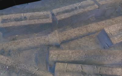
The other issue, that I believe the IMAGE project can help resolve, is that there’s no accurate map of entire reef areas to show where the sponges are alive and where they are dead. So how can we accurately say fishing activity is continuing to damage the recovering of the sponges? There’s simply isn’t even a baseline. There have been transects by ROV (Remote Operating Vehicle) or drop camera, but these only show very narrow sections of the reefs, but not the full picture.
What are the main consequences that can already be seen in this environment? Can that be reverted?
There’s visible physical damage in the area from fishing activity, so there’s physical damage showing both from trap lines and from downriggers. What’s happening is these downriggers are slicing through the sponge smashing it, but there’s still a lack of understanding and, more importantly, appreciation from fishers that their actions have significant impacts on these habitats. And that these habitats support the very species they are trying to harvest.
The other thing that’s been documented is that warming water temperatures will impact these reefs. Over the years, there’s significant increase in temperature at the shallower sites, at around 45 – 50 feet, where the sponges are much more susceptible to climate change or warming waters. And that leads to, can it be reverted? Possibly! For many years, the only published papers on damaged sponge, show that once a sponge was damaged, it died. But there is definitely potential for recovery. It has been shown that some of the damaged sponge will recover if there’s enough mass, larval settlement events and the right conditions. And I think having the visual representation of how truly damaged these reefs are, and where the healthy and unhealthy portions are through the IMAGE project, it would be incredibly helpful.
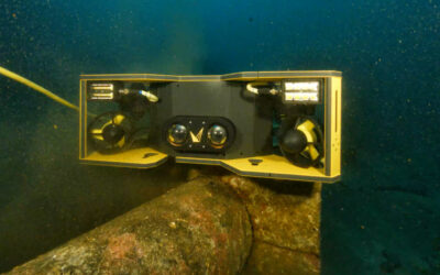
How can high-resolution images and 3D models help with research and preservation?
We need a survey that will tell us which sponges are alive and which are dead, and their locations – this is the only way to improve the enforcement of fishing closures and improve the education around these habitats. If we know the precise condition of the reefs, we know exactly when there are new damages.
So, having a baseline of what currently exists is very important but also tracking it over time and showing existing damage and new damage that happens here. It’s been hard to tell the story of the reefs and their importance without coloured images and mapping, and high-resolution laser scan will give accurate data on the conditions of the environment.
What information would you like to get from these non-intrusive AUV-based mapping operations?
By creating a baseline of what these habitats look like now, knowing where the reefs are alive and where they have already been damaged, we will be able to determine any change in the region and identify illegal fishing operations. And if we have proof of illegal activity, we can demand greater enforcement of the laws.
We also hope that clear images and data will help people understand the importance of this fragile ecosystem and why we must preserve it. We really want to increase awareness of the importance of the region.
Many areas in the Howe Sound region are protected by fishing closures. Are those measures effective? Would optical data help prove the importance of a bigger enforcement of these protective measures?
Voyis’ cameras and laser scanners can provide visual proof – like coloured images – of damage and especially of the scale of the damage. Some people are visual learners, or they don’t believe unless they can see it. So if for example, we’re in a stakeholder discussion and the fishing lobby saying “Oh, we don’t do damage” or “Reefs just grow back”, we can have a visual map or visual representation of damage, especially if it’s new damage that shouldn’t have occurred because of the closure, it’s very hard for them to argue that. So, you know that that’s important.
The second point touches on the rockfish monitoring project, which we just applied for funding for. Rockfish are like their name, they like to hide in rock piles and cracks, and they’re very associated with complex bottom. So, if for example, you’re scanning and mapping these protected areas and you’re finding great complex habitat that should have a lot of fish, but it doesn’t, it indicates fishing pressure, same with the presence of fishing gear and so on.
What is the main message you would like the public to hear about the preservation of glass sponge reefs in Howe Sound?
We have a global unique ecosystem that coexisted with the dinosaurs and it’s right off our shores. Like there’s one a couple hundred meters from where I live, where for generations, my family had fished and caught rockfish and it all ties together. I think there’s just a lack of understanding and appreciation of the role these reefs play in the environment and there needs to be more, not just more enforcement but there needs to be more research. There needs to be more opportunities to tie the role they’re playing in the ecosystem into storytelling., to increase awareness.
And if we don’t act on enforcement and protection, they may not be there to study anymore.